
Landform-Based Planting Guide
- Feb 11, 2025
- 3 min read
HSC commissioned Wildland Consultants to develop a landform-based planting plan for the Hakataramea catchment. The plan identifies indigenous plant species suitable to be planted on different landforms within the catchment. This information was sought to better inform planting projects and to guide plant selection in the Community Native Nursery for supplying the catchment and similar areas in the region.
The development of the plan involved a visit to the catchment to study the landforms and vegetation and a thorough review of information available to compile the comprehensive report. Click the link below to download the full report or read on for a summary of the various landforms and recommendations.
The plan identified nine landforms and habitats within the catchment, click on arrows next to each landform name below to expand for more information.
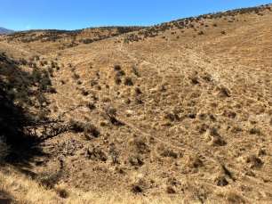
Low elevation sunny scarps
Sunny north-facing scarps at low elevation probably did not support indigenous forest because they were too dry, but would have supported woody vegetation comprising shrubland and scattered indigenous trees. The main shrubs would have been matagouri, porcupine shrub, Coprosma crassifolia, and Coprosma virescens with desert broom (Carmichaelia petriei), prostrate kowhai (Sophora prostrata) and corokia (Corokia cotoneaster) at lower abundance. Scattered trees would have included kowhai, ti kouka/cabbage tree, makahikatoa (Kunzea serotina), and fierce lancewood (Pseudopanax ferox). If closed forest is desired on these dry landforms, it would be best to try an appropriate species of pine (Pinus spp.).
Dry plains
Dry plains would have supported similar vegetation to sunny scarps, but may have had taller woody vegetation, for example makahikatoa woodland. Makahikatoa, matagouri and porcupine shrub should form the majority of plantings in these habitats. Trees such as kowhai, fierce lancewood, and ti kouka/cabbage tree could be planted at a later stage once shrubland has established.
Dry hillsides
Dry hillsides would support all the species from dry scarps, but have deeper soil, especially on toeslopes, so would have supported a dry forest vegetation in pre-human times, with areas of shrubland on particularly thin soils. Indigenous trees on these hillsides would have included kowhai, fierce lancewood, ti kouka/cabbage tree, kōhūhū (Pittosporum tenuifolium), makahikatoa, and mapou (Myrsine australis).
Upland rocky habitats
Rock outcrops would support most of the species referred to on the dry hillsides, but with a reduced selection of indigenous trees (refer to the report for more info). Coprosma crassifolia would be the main shrub around rock outcrops.
Low elevation shady scarps
Shady scarps at low elevation would have supported indigenous forest, but not comprising tree species that require deep, productive soils. Kapuka/broadleaf, tī kouka, and makahikatoa should form the bulk of plantings on these scarps. Trees can be planted directly into the matagouri shrublands that are currently present on many of these landforms.
Moist hillsides
Moist hillsides are present on south-facing slopes of gullies and often support dense shrubland. These shrublands can be planted into with indigenous trees, and will help shelter them and deter ungulate browsers. Kapuka/broadleaf, piripiriwhata/marble leaf, tī kouka/cabbage tree, horoeka/lancewood, and kōhūhū should form the bulk of plantings. At higher elevation (up to 900m), the trees and shrubs identified in the report can be planted directly into tussock grassland. While indigenous forest would have been historically present above this, planting higher is not suggested because of stronger exposure and lower productivity near the natural treeline.
Low elevation riparian terraces
Low elevation riparian terraces have been extensively invaded by crack willow. Willows will need to be removed and subject to ongoing control if planting in these sites is considered. These are highly productive sites, however, so growth rates of indigenous trees will be fast in these habitats if willows are cleared. Species that could be planted in these moist, productive habitats include large trees such as manatu/lowland ribbonwood (Plagianthus regius), matai (Prumnopitys taxifolia), narrow-leaved lacebark (Hoheria angustifolia), kapuka/broadleaf, and kōwhai. Lowland ribbonwood will be one of the fastest-growing trees in these habitats.
Marsh wetlands
Marsh wetlands are productive wetlands on mineral soil, that have a fluctuating water level. Marshes always need a hydrological agent that gives them the fluctuating water level. They can be found adjacent to rivers, lakes, and the coast. In the Hakataramea catchment will often be present on lower river terraces that are regularly flooded, and may occupy old flood channels that pass through non-wetland habitat. Riverine marshes are the habitats of species that can cope with flood disturbance, so often are vegetated in sedges, grasses, and rushes.
Swamp wetlands
Swamp wetlands differ from marsh wetlands by having a permanently high water level. In the southern, South Island they are typically occupied by harakeke/flax (Phormium tenax), raupo (Typha orientalis) and/or pukio (Carex secta) but also can include woody species such as mingimingi and tī kouka/cabbage tree in areas where the water level isn’t too deep.
HSC would like to thank Kelvin Lloyd and the Wildlands Consulting team for the preparation of this report.


Comments